
Hiking Norvan Falls
Stats for Norvan Falls hike:
Length: 14 km
Elevation Gain: 345 m
Difficulty Level: Easy
Norvan Falls is located in Lynn Headwaters Regional Park in North Vancouver, British Columbia, Canada.
It’s a 14 km out-and-back hike. Elevation gains is about 345 m. It takes about 4 hours in total to hike the trail out-and-back. The first 2 km of the trail is a wide and open logging road (yes, it was a logging site in the early 20 century). The next 2 km it becomes narrow and muddy.
At around 4 km, you come to a plateau called third debris chute. If the weather is good, you can see some mountains in the distant. It’s a good place to take a rest.
After that, you have to cross a few streams and dry creeks. There is a little bit of ascending in the last 1 km or so close to the waterfall, about 200 meters elevation.
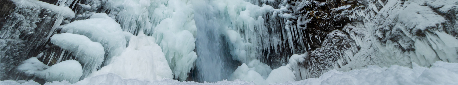
At the end of the hike is the beautiful Norvan Falls.
Temperature in Vancouver area usually is not cold enough to completely freeze any waterfalls. However, once in a blue moon, during a cold snap, it is so cold in Vancouver that some waterfalls are at least half frozen. Norvan falls is one of them. In this post, there are some photos of half frozen Norvan Falls and some snowy sceneries around the waterfall for you to enjoy.
If you like hiking to a waterfall, you can checkout my hikes to Golden Ears, Swan Falls, Steelhead Falls and Cascade Falls, Crooked Falls, Kennedy Falls, Cypress Falls, and Sawblade Falls and Woodland Falls.


2 thoughts on “Norvan Falls”
Comments are closed.